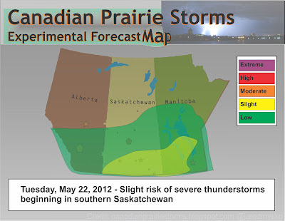
The Experimental Severe Weather Forecast Map is back this year and has been rebuilt from scratch using Corel Draw X6. It will be updated daily using forecast data from Environment Canada and information supplied by The Arctic And Prairie Storm Prediction Centre. Originally created in 2003, this will be version 3 as it began from Windows Paint program then onto Adobe Illustrator in 2006.
Another addition to the site is a live feed from our list of storm tweeters, including chasers, spotters, meteorologists, The Weather Network and many other weather and local news feeds.
Also, added another lightning detector from Hanna, Alberta to our data links page.
Today's map will always be displayed on the top right hand side of the page and is not of any official relation to Environment Canada. It is designed and created by @jaredmysko so please direct comments and criticisms on twitter for public display and analysis. Warning criteria will almost always appear slightly higher here in order to create public awareness and encourage debate on the topic. Thank you and have a great day!
Jared Mysko
Tuesday's Map (preliminary forecast)
Today's Song via YouTube Music
Canadian Prairie Storms Pages
Monday, May 21, 2012
Subscribe to:
Post Comments (Atom)
Pages
- Home
- Weather Data Links
- Social Media
- LIVE Storm Chase Feeds
- Tornado Fatalities in Saskatchewan 1898 to 1979
- June 1st, 1986 Three Tornadoes Strike Saskatoon's North End
- Education and History
- Storm Chasing/Meteorology/Weather Sites
- Risk Map Archives
- 2012 YEAR OF TORNADOES IN SASKATCHEWAN (video playlist)
- 2004 Photos
- Photos 2003
- Photos 2002
- Terms of Service / Privacy Policy


No comments:
Post a Comment