Sunday, July 26, 2015

Storm Systems Merging Overnight - Extremely Dangerous Situation On Monday

All signs are pointing to a very dangerous situation on Monday across southern Saskatchewan and southern Manitoba. Heavy rains, flash flooding, large amounts of precipitation are expected from Swift Current to Brandon starting early in the morning from nocturnal thunderstorms that may become strong to severe late tonight. Strong tornadic supercells are expected along the North Dakota/Saskatchewan/Manitoba borders early in the afternoon. Systems from Alberta will be moving quickly eastward while Manitoban storms will drop south and collect in a back-building formation in North Dakota. By early afternoon, it is expected both systems will come together over south eastern Saskatchewan with strong tornadic supercells moving north across the border from North Dakota.

Please monitor Environment Canada Warnings closely. This may become a very dangerous situation. Forecast models may change locations drastically overnight depending on how things line up. Have a safety plan ready but remember, this is only a forecast. Updates to the risk area map will be posted as required and please remember to keep reports to a workable minimum with accuracy of location and size of hail using coins or measuring device in photos. Rapid rotation reports are always best served with a short video when in a safe location.

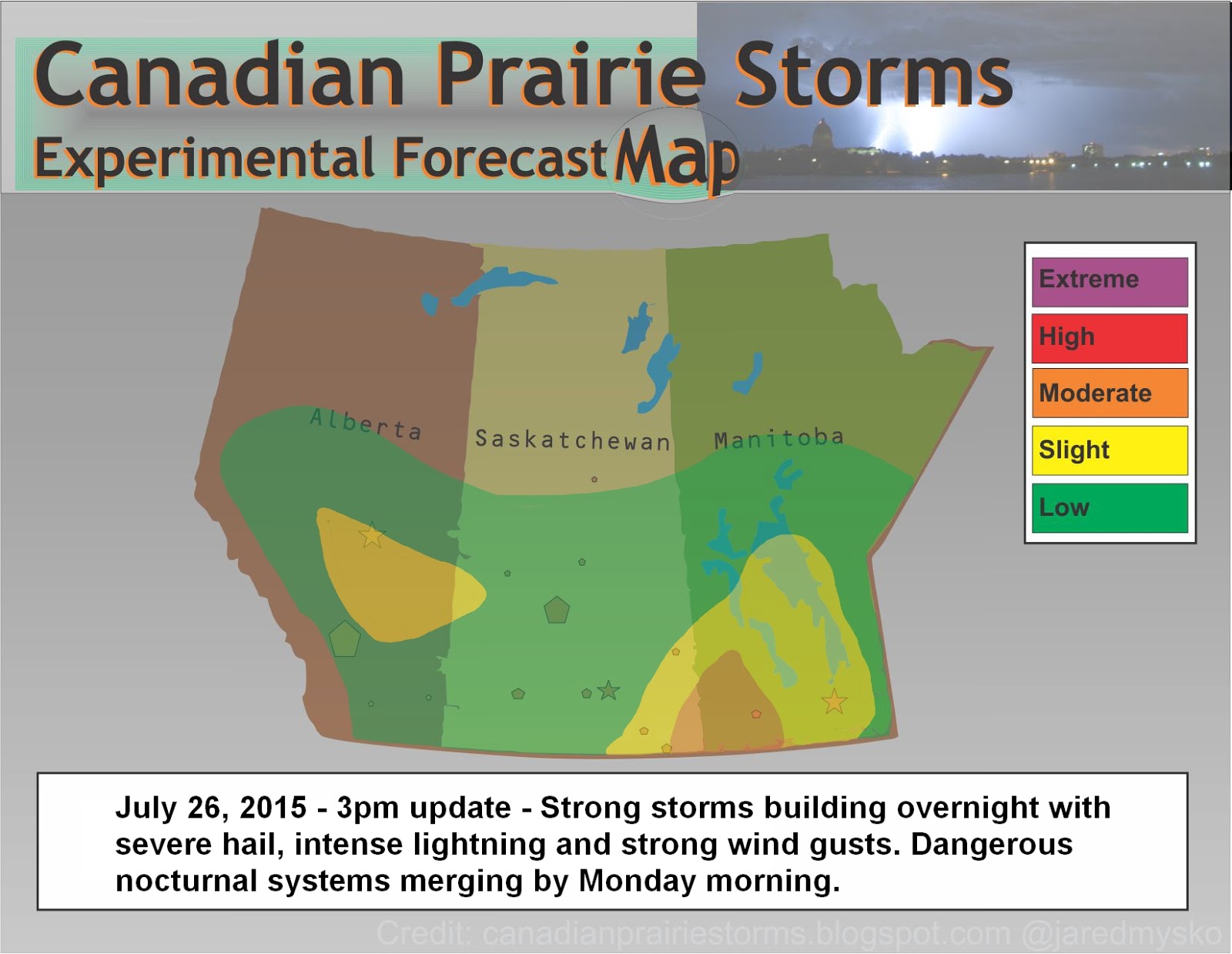
Here is the forecast map for this evening and overnight with tomorrow's expected outlook "Day 2":


Wednesday, July 22, 2015

Updated Risk Map - 2:30pm - Severe Weather Outbreak In Progress

Here is the updated risk map as of 2:30pm:


Just after noon time in Calgary and flurry of funnel cloud reports came in. As of right now, the main system has exited city of Calgary and is still growing and moving east. No confirmed tornado touch downs but many photos suggested it very close. Large hail and downpours were also reported.

Here is a zoomed in view of Calgary radar as of 1:50pm - Two dangerous areas, both seem to be rotating on radar. Northern circle is much wider/slower, while the southern circle is the funnel producers with much tighter/faster rotation and the main area to watch. South east corner of a east bound tornadic supercell is usually where it will produce tubes.


Twitter #abstorm highlights from earlier this afternoon:


Tons more can be seen via the #abstorm feed on the right side of this page.

Also, the latest updates will be posted on our Facebook page.
Please like, share, comment and post your footage when safe to do so.

Storms are moving east and expected to continue all afternoon and late into the evening.

Tuesday, July 21, 2015

Today's Outlook Map [Moderate Risk] - Plus: Yesterday's Summary Of Events

Here is today's severe weather outlook map:


Storms should begin to fire up early this afternoon and last late into the evening. Large hail and damaging wind gust will be the main feature of today's storms.

Yesterday afternoon, storms started extremely strong with two main cells (Lethbridge and Edson) both going purple on radar from the beginning and producing reports of hail the size of golf balls or slightly larger. After initiation, these storms morphed into a linear MCS (mesoscale convective system) producing intense lightning and incredible shelf structure, losing most severe qualities before hitting the city of Edmonton.

REMINDER: When reporting hail to #abstorm #skstorm please use a measuring tape, ruler, coins or golf ball, baseball, softball, etc.. Accuracy in measurement is very important in determining potential damage and risk to future regions. Photos of holding hail in your hands is not acceptable as people have different sized hands. Another common mistake is reporting marble size hail. Marbles also come in various sizes. If it is very small hail, please report as pea size.

***The best way to report is taking a photo with a measuring tape held beside the hail stones***

Here are some tweets of the action in Alberta last night: